I have an article published in Highways Magazine, the text of which is below.
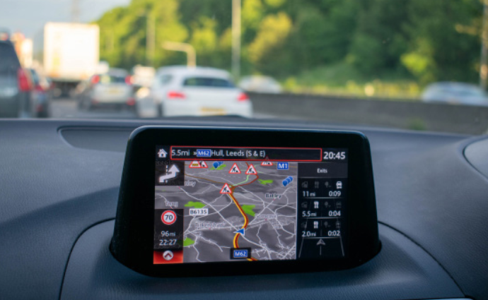
Recent advances in a number of digital technologies in combination are having a significant impact on travel behaviour on the road network by providing route guidance that takes account of traffic conditions. What may be termed ‘digital navigation’ involves the use of satellite navigation (satnav) to provide spatial positioning to high precision; digital mapping; the ability to detect vehicle speeds and hence the location of traffic congestion; and routing algorithms to optimise journeys. The combination of satnav location and digital mapping provides a navigation service that offers turn-by-turn route guidance.
While digital navigation is in widespread use by road users, remarkably little information is publicly available about performance, in particular how routes are optimised, the suitability of recommended routes, the accuracy of estimated journey times, and the impact on the functioning of the road network as a whole. Nevertheless, there is evidence to indicate an impact on the use of minor roads, of major roads, and on traffic congestion and the optimisation of the road network.
Recent revisions to British road traffic statistics appear to show that there has been a substantial growth of motor vehicle traffic on minor roads in recent years, an increase of 26% between 2010 and 2019, while traffic on major roads increased by only 12%. One factor contributing to this growth is the increase in van traffic, including that arising from the growth of online shopping with home deliveries. However, in 2019 van traffic amounted to 15% of traffic on urban minor roads, and 19% on rural minor roads, cars being responsible for 82% and 78% of traffic respectively. So, the growth of van traffic on minor roads has been responsible for only part of the overall traffic growth on these roads.
The most likely main contribution to the large growth of traffic on minor roads is the widespread use of digital navigation, which makes possible the general use of minor roads that previously were largely confined to those road users with local knowledge, as well as extending such local knowledge. Diversion to minor roads is likely to occur when major roads are congested and represents an effective increase in the capacity of the road network, so generating additional traffic.
As well as encouraging use of minor roads, digital navigation may divert traffic from local roads to roads intended for longer distance traffic. One case that I have analysed where such diversion may have occurred is the widening of the M25, the London orbital motorway, between junctions 23 and 27 to the north of the city. There was substantial growth in traffic above the level that had been forecast, much of which arose from diversion of local trips, such as home to work, to take advantage of faster travel on the motorway, despite the greater distance and higher fuel costs incurred. The contribution of digital navigation in facilitating such diversion cannot be inferred from available data, but it is plausible. Regular users of digital navigation would have up-to-date information for each journey, while irregular or non-users would likely be aware that diversion to the motorway would offer the fastest journey.
The M25 case study suggests that local traffic may be expected to take advantage of the capacity increase of major routes in the vicinity of urban areas that generate much traffic, which are the locations where the Strategic Road Network is under greatest stress and where investments to increase capacity are thought to be most needed. However, this local traffic negates the benefits expected for long distance road users and so undermines the economic case for the investment. The growing use of digital navigation would tend to contribute further to weakening the case for such investment.
While the M25 case study is an illustration of the maxim that we can’t build our way out of road traffic congestion, nevertheless the development of digital navigation offers probably the best means available to mitigate the impact of congestion. Congestion arises in or near areas of high population density and high car ownership, where the capacity of the road network is insufficient to cope with all the trips that might be made. Drivers are deterred by the prospect of time delays and so make other decisions – to travel at a different time, by a different route, by a different mode, to a different destination (where there are options, as for shopping), or not to travel at all (by shopping online, for instance). Congestion is therefore substantially self-regulating, in that if traffic increases, delays worsen and more potential users are deterred on account of the time constraint.
Digital navigation that takes account of congestion in real time can offer less congested routes, so making better use of the existing road network and reducing road users’ exposure to congestion. One problem that may arise is that traffic may be diverted on to unsuitable roads, where local environments and neighbourhoods may be adversely affected, or even where large vehicles can become obstructed. Diversion onto unsuitable routes is a problem that could be mitigated through collaboration between digital navigation providers and road authorities.
Beyond the rerouting of traffic to less congested roads, there is a feature of digital navigation that mitigates the unwelcome experience of traffic congestion – the prediction of journey time, or estimated time of arrival (ETA). When road users are asked about their experience of congestion, both in surveys and in discussion, the evidence from their responses indicates that the uncertainty of journey time is a more important adverse consequence than lower speed. Accordingly, an important benefit of digital navigation is the forecast of ETA in the light of prevailing traffic conditions on the selected route, in this way substantially reducing journey time uncertainty.
While diversion onto less congested routes may be helpful for users of digital navigation, there is a question as to whether this is optimal for users of the road network as a whole. Digital navigation employs proprietary algorithms whose performance is difficult to assess externally. An algorithm might response to build up of congestion by diverting all traffic to a single alternative route until that became congested, repeating the process to spread traffic across available routes until congestion abated. Or the algorithm might spread traffic across all available routes at the outset. And the algorithm might anticipate the build-up of congestion based on historic experience. But in any event, the routing algorithm used by one provider would not take account of the activities of another provider. The providers of digital navigation services are very secretive and there is almost no published information on their design and performance.
The road system is generally well regulated to achieve safety and efficiency. Given the potential scale of impact of digital navigation devices on network operations, arguably a licensing regime would be appropriate for providers. This might require information to be exchanged with road authorities, guidance to be accepted to avoid adverse environmental and social impacts, and mutual collaboration to optimise the operational efficiency of the network as a whole, while at the same time optimising the experience of individual road users.