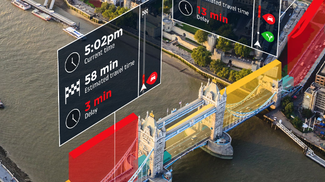
I have previously drawn attention to the impact of Digital Navigation (DN) of travel behaviour. The providers of this service, commonly known as satnav, respond to requests from users by providing routing options and journey times that take account of prevailing traffic conditions. Here I want to consider how this is achieved.
There is only fragmentary published information on how the routing algorithms function. It appears that a model of travel behaviour on the road network is constructed from trip data derived from users of the navigation service: trip origins, destinations, routes through the network, time of day/week, prevailing traffic conditions, journey times. Such a model may be analogous to a microsimulation model, but using observed trip data rather than synthetic data. It could also be viewed as combining the trip generation, distribution and assignment stages of the standard four-stage transport model (the mode split stage not being relevant for committed road users seeking routing advice).
Providers of DN offer predictions of journey time in advance of setting out. Comparison of predicted and outturn journey times provides a check on the validity of the model. Machine Learning has been employed to improve the accuracy of journey time predictions of Google Maps.
The type of model developed by DN providers is novel and powerful in that it can utilise huge amounts of trip data, both real time and historic. A question is whether such models could be used to inform decisions on road investments and other interventions aimed at improving experience on the road network. That is, could the DN models replace conventional transport models for planning purposes?
The DN models already exist. Their cost of construction and operation is met by the income generated from sales, whether of direction services to business premises (e.g. Google Maps) or to vehicle manufacturers that fit DN as standard equipment (e.g. TomTom). So, the cost of using these models for planning purposes could be less than for building and using conventional models.
TomTom offers Origin Destination Analysis as a service and may therefore be open to suggestions for use of the underlying model for planning purposes.
Another possibility would be to create an open-source, crowd-funded DN model – a kind of not-for-profit version of Waze, a provider that encourages user input. The funders might be road authorities that would gain access the the underlying model for planning purposes.
A further possibility arises from the likelihood that some form of electronic road user charging will be introduced, as electric propulsion replaces the internal combustion engine, to replace revenue from fuel duty. This is likely to involve technology similar to DN, and might therefore be the basis of traffic modelling for other purposes.
DN is both changing travel behaviour and generating new travel models to inform public policy. We may be at the beginning of a new era of travel and transport analysis.